Floodplain Regulations in Wisconsin
Recent devastating floods in Texas have resulted in over one hundred deaths, highlighting the serious, life-threatening issues related to flooding. While current coverage has highlighted the importance of warning systems, building regulations also play a significant role.

Flooding near the lakefront in Milwaukee.
History of Building Codes and Disasters
Current building code regulations have often been shaped by disastrous events that resulted in loss of life and property. The London fire of 1666 spawned one of the first building codes, and the Triangle Shirtwaist Factory Fire in New York City led to modern egress requirements. The danger of earthquakes on the West Coast has led to location-specific seismic design requirements, while the devastating hurricanes that barrage Florida have led to the Miami-Dade certification for building materials designed to resist high wind velocities.
At the end of the day, building codes are designed to manage risk and, hopefully, to eliminate loss of life and reduce loss of property when disasters do occur.
Settlements have been built next to bodies of water since the beginning of civilization. Water irrigates crops, creates fertile farmland, and can be used as a source of drinking water and waste management for people and livestock. Before trains, or planes, or cars, water travel was the primary transportation network. It powered the mills of industry in New England and provided electricity for the Tennessee Valley. Land has been reshaped by development and even reclaimed from water, as is the case in New Orleans. Even if some of these functions have diminished in importance, we still build near water to use it for recreational purposes or just to enjoy the view.
So there is good reason to build near water, but also risk. Sea and lake levels rise and fall over time. Dams and levees are breached. Tsunami waves and storm surge ravage coasts. And rivers flood.

Galena, Illinois (depicted here in a 1845 lithograph) was once a great Mississippi steamboat capital before the river silted in. The city is subject to periodic flooding.
Public Domain Image. Accessed from the New York Public Library https://digitalcollections.nypl.org/items/d39ec5c0-c5ed-012f-eec9-58d385a7bc34

When I visited Galena in July 2025, the city had a large dike constructed by the Army Corps of engineers to mitigate flooding in the downtown. The image shows one of the massive floodgates. The red line on the small white sign indicates the high water mark of the July 28, 2011 flood.
Flood Regulations in Wisconsin
In 1968 the U.S. Congress created the National Flood Insurance Program (NFIP). This program offers flood insurance to communities that adopt its standards. These standards include very specific building regulations. When new flood insurance studies are made, FEMA and the DNR require municipalities in Wisconsin to update their ordinances in order to stay in the program. As a result, many municipalities in Wisconsin have incorporated floodplain regulations into their codes. FEMA publishes a community status book that lists all municipalities in the US and whether they are part of the NFIP.
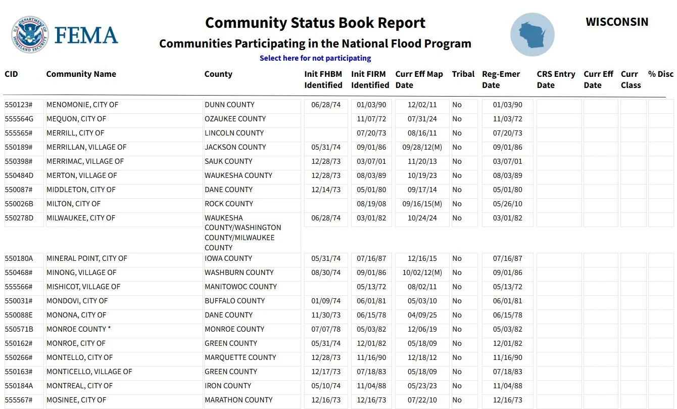
Screenshot used under fair use for educational purposes
The newest model ordinance for Wisconsin was developed by FEMA and the DNR in 2022. As FEMA develops new flood insurance studies for areas in Wisconsin, municipalities are adopting this updated model ordinance. The model ordinance can be found here. (Fun fact: the model ordinance has a provision that can be included for municipalities with cranberry farming, since flooding the fields is part of the cultivation process)
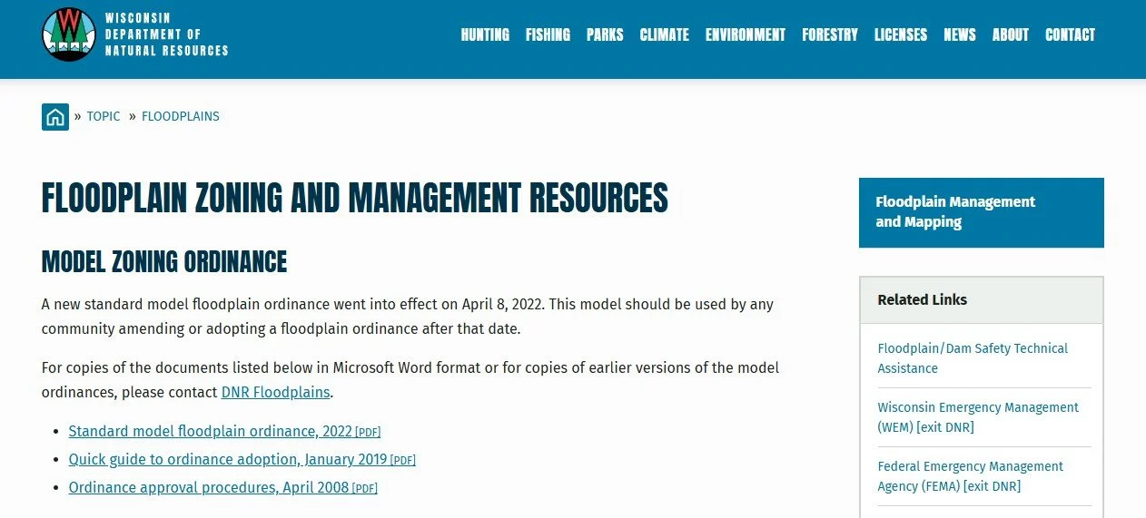
Screenshot used under fair use for educational purposes
What are the Requirements of this 2022 Model Code Related to Residential Construction?
It is first helpful to define a few terms. A floodplain is the area that is covered with water during a flood. Within the floodplain there are two separate sub-areas – the floodway and the floodfringe. The floodway is the most dangerous area that during a flood has moving water. The floodfringe is the area that is damaging, but not quite as dangerous, and is characterized by standing rather than moving water.
For the purposes of regulating which areas are at risk of flooding, FEMA sets the base flood elevation (BFE), which is the flood elevation that has a 1% chance of occurring in any given year (also known as a one-hundred-year flood). They will further divide the floodplain area into the floodway and floodfringe.
When FEMA can’t determine exactly where the floodway boundary is, they will use zone designations to indicate the risk. For the purposes of this post, I’m only going to break down regulations for the floodway and floodfringe, but it's important to know that there are separate requirements when the floodway boundary has not been determined for an area.
To determine whether a property is wholly or partially within a floodplain, you have to consult your specific municipality’s adopted floodplain ordinance to identify the precise maps to reference for the official result.
As a preliminary research tool, FEMA publishes an interactive map online. It can be found here.
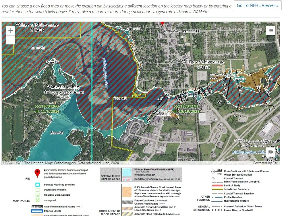
This map showing part of the Village of Mukwonago and unincorporated areas shows the 1% floodplain area, which includes the dangerous floodway (red striped area) along with the less dangerous but still highly regulated floodfringe (solid blue areas).
Screenshot used under fair use for educational purposes
Building in a Floodway
Habitable buildings are not allowed. Period.
Building in the Floodfringe
Homes can be built in the floodfringe area, but the model ordinance provides three main provisions to limit the risk to people and property.
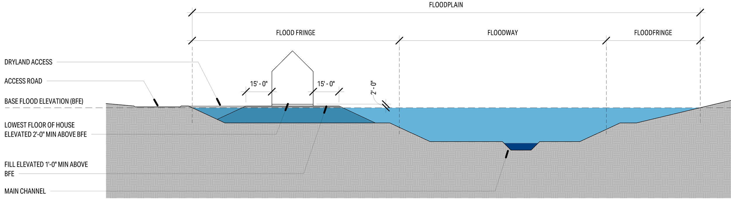
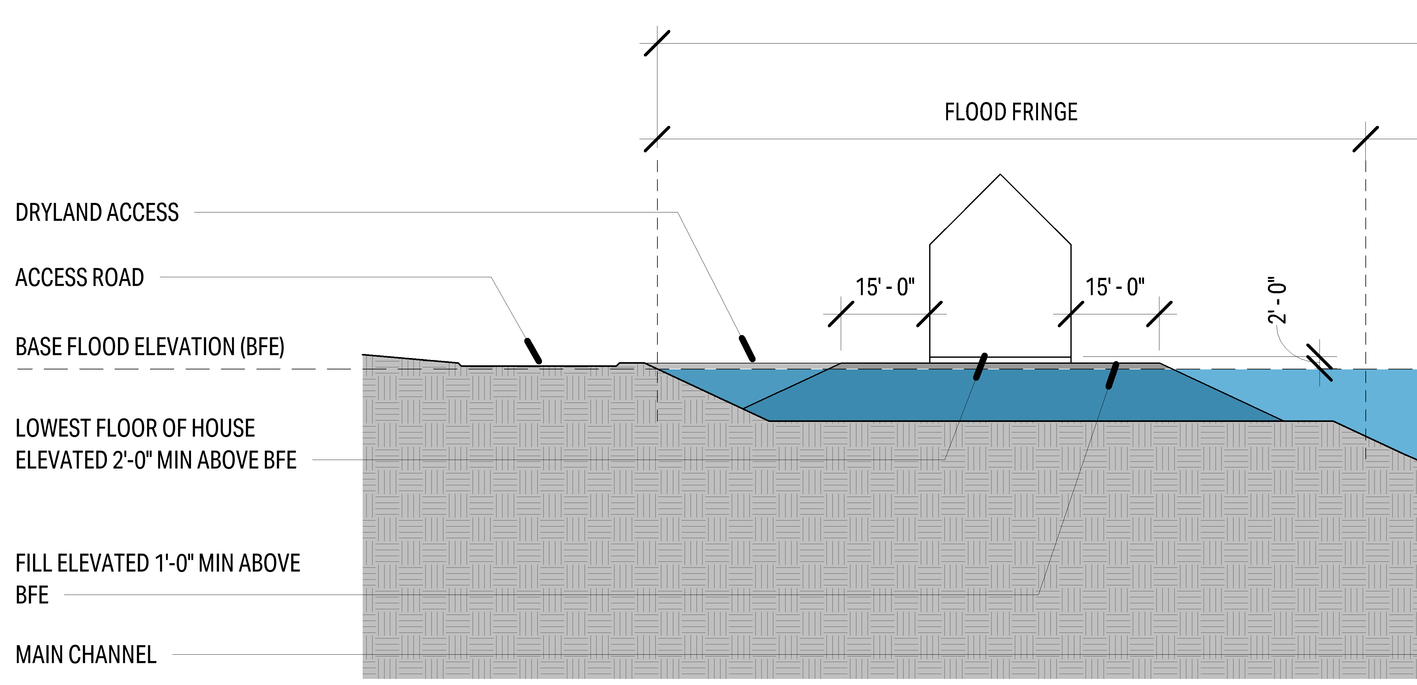
Provision 1 - The house has to be elevated on fill a minimum of 1’-0” above the Base Flood Elevation. This has to extend out from the house 15’-0” in all directions. The code also requires extensive engineering documentation showing that this fill will not substantially change local flooding elevations.
Provision 2 - The lowest habitable floor (including a basement floor, if applicable) has to be at or above base flood protection elevation (2’-0” above the base flood elevation per the ordinance definitions). If the structure has a basement or crawlspace floor at base flood elevation, the foundation has to be fully waterproofed and requires extensive engineering to ensure that it can withstand special forces from flooding. Basement or crawlspace floors are not allowed in any case below base flood elevation.
Provision 3 - The model ordinance requires that the structure has dryland access (access to areas outside the base flood elevation). There is a special exception if the public access road for your property is below base flood elevation, but this exception comes with its own rescue requirements for the municipality to meet that it may not grant you.
What if an Existing Home is Within the Floodfringe?
If an existing building was lawfully constructed within a current floodfringe area prior to a current floodplain ordinance, this property can remain and be improved up to 50% of the property’s current value. Any improvements beyond 50% of the initial value are going to trigger the full requirements of this ordinance, including base fill, elevating the lowest floor, and dryland access.
Flood ordinances and maps can change over time, so it's important to stay on top of current regulations. A home that was up to code at one time may one day be at risk of flooding and subject to new regulations.
Conclusion
Flooding is a serious issue, and building in a floodplain is a risky endeavor that is heavily regulated to reduce that risk. At Platform House Plans, we will check a property for floodplain regulation impact during the feasibility stage of a project. If you’re considering purchasing a waterfront property or if your property is near a body of water, reach out to Platform House Plans and we can identify if there will be floodplain regulation impacts on your project.